North Oconee River Greenway
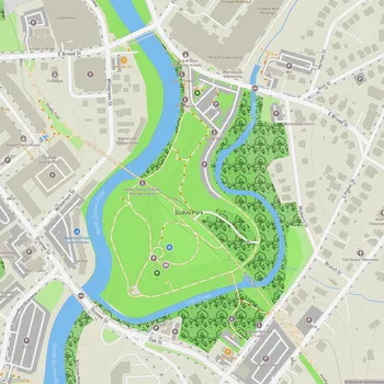
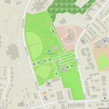
Interactive Park Map
About North Oconee River Greenway
Trail System
The North Oconee River Greenway weaves about 8 miles of smooth paved trails through Athens, great for anyone looking to enjoy the outdoors without a motor in sight. You'll also find some natural hiking paths if you prefer the feel of earth beneath your feet. The main paved trail stretches from the Sandy Creek Nature Center up north down to Bailey Street and Carriage Lane in the southern section.
As you make your way along the path, you'll catch beautiful views of the North Oconee River, wander through the serene Dudley Park, and pass notable spots like the historic Oconee Hill Cemetery and Carr's Creek. The trail draws all sorts of people - joggers getting their miles in, folks out for a casual stroll, cyclists cruising by, and dog parents giving their furry friends some exercise. Thanks to the wide, well-kept paths, there's plenty of room for everyone to share the space without feeling crowded.
Heritage Trail
If you're a bit of a history buff, don't miss the half-mile Heritage Trail section between Dudley Park and Wilkerson Street. This compact green space features over 50 interpretive panels that tell the story of Athens' past - everything from the significance of the North Oconee River to local industries and the people who've called this area home through the years.
Environmental Benefits
The greenway does not only give us humans a place to play. It is a vital wildlife corridor, creating space for local creatures to live and move freely.
Planning an event? Make a reservation at this park
It also plays an important role in keeping the river healthy by creating a natural buffer zone that filters runoff and helps prevent erosion. And on those hot Georgia days, you'll appreciate the abundant shade trees that line the path, keeping things surprisingly cool even when the temperature climbs.
Amenities
You can find thoughtful touches throughout the greenway to make your visit more comfortable. Benches are placed strategically along the route for when you need a rest or just want to sit and watch the river flow by. There are also picnic areas with covered tables at certain spots if you want to bring along some food.
Dog owners will appreciate the pet waste stations with bags and trash cans at the parking lots, plus water stations to keep your four-legged friend hydrated. Just remember that dogs need to stay on leash at all times.
Been to this park? Share a or a
If you're bringing little ones, there's a playground near the Sandy Creek Nature Center entrance, conveniently located right by the parking lot so you don't have to trek far with tired kids.
Connections and Access
One of the best things about this trail system is how it connects important spots around Athens, including the Sandy Creek Nature Center, North Oconee River Park, and the University of Georgia campus. It's not just for recreation - many locals use it as an alternative transportation route, linking residential neighborhoods, downtown Athens, and the university.
You can hop on the trail from several parking areas, including at Sandy Creek Nature Center. If you're up for a longer adventure, the round trip from Sandy Creek Nature Center to Carriage Lane and back covers about 14 miles - well-suited for a satisfying bike ride.
The greenway welcomes visitors daily from 7AM to 8:30PM, and it's completely free to use year-round, as long as the weather cooperates. Note that after heavy rains, some of the lower sections of the trail might flood, so plan accordingly.
All Features & Facilities
Nature & Wildlife
Water Features & Activities
Visitor Services
Food & Gathering
Photo Gallery
Leave a Comment
ParkMagnet Score
Good Park
Park Size
Opening Hours
Plan Your Visit
Weather
Top Restaurants Near North Oconee River Greenway
J & L Buffet
0.4 miles1119 Dr Martin Luther King Jr Pkwy, Athens, GA 30601
A casual buffet restaurant serving hearty Southern comfort food including fried chicken and traditional sides.
South Kitchen + Bar
0.4 miles247 E Washington St Ste 101, Athens, GA 30601
Contemporary Southern restaurant featuring elegant atmosphere with New Orleans influences and creative vegetable dishes.
Athens Bagel Company
0.4 miles268 N Jackson St, Athens, GA 30601
Authentic boiled and baked bagels served with housemade cream cheese in a charming historic setting.
Top Hotels Near North Oconee River Greenway
Hotel Indigo Athens Downtown - Univ Area, an IHG Hotel
0.3 miles500 College Ave, Athens, GA 30601
A stylish downtown hotel featuring modern rooms, an on-site restaurant, bar, and convenient access to local attractions.