Hidden Falls Regional Park
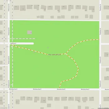
Interactive Park Map
About Hidden Falls Regional Park
Natural Setting
Tucked along the Mississippi River in Saint Paul, Hidden Falls Regional Park spreads across 130 acres of floodplain forest and bluff land. It's a refreshing natural escape from the urban bustle that surrounds it.
True to its name, the park features a modest spring-fed waterfall nestled within the woods. While you might find the falls running dry during some less rainy periods, when flowing, they create a serene little sanctuary. You can reach this signature feature via a limestone staircase that connects to East River Parkway. It's just a short walk from the parking lot, however the path could definitely use some clearer signage (we nearly missed it our first visit!).
Recreational Opportunities
The park offers about 6.7 miles of paved trails that wind through shady woodlands and along the Mississippi's shoreline. If you're walking, running, or cycling, these paths connect seamlessly to the broader regional trail system. If you're feeling a bit more adventurous, dirt hiking paths cut through the more untamed areas - just be ready for the occasional fallen tree and, depending on the season, some mosquito companions.
Planning an event? Make a reservation at this park
With its riverside location, the park naturally attracts fishing enthusiasts and boaters. It's also a prime spot for wildlife watching, especially for birds traveling the Mississippi Flyway migration route. If you're lucky and visit during nesting season, you might even catch a glimpse of an eagle's nest with baby eaglets inside - a truly special sight.
The park includes several picnic areas, well-maintained boat launch facilities, and open spaces for whatever outdoor activity strikes your fancy. The boat launch deserves special mention for accommodating everything from kayaks to trailered boats, offering easy river access to nearby attractions like Ford Lock and Dam, Minnehaha Park, and Fort Snelling State Park.
Park Amenities
Around the park, you can find picnic areas complete with tables, benches, and BBQ grills - ideal for anything from a solo lunch break to family gatherings during the warmer months. Some picnic shelters have restrooms nearby, which is always convenient.
Been to this park? Share a or a
While there's no formal playground equipment, the park offers plenty of open grassy areas where kids can run wild and connect with nature. The sandy riverside beaches are great spots for hunting interesting rocks or practicing your stone-skipping technique.
As for facilities, you'll come across both permanent restroom structures (typically open seasonally) and portable toilets near picnic areas and the main shelter. Water fountains are somewhat limited, so it's a good idea to bring your own water, especially during those hot summer days.
Historical Significance
This isn't just any park - it's a piece of Minnesota history. Originally selected as a park site in 1887 by landscape architect Horace Cleveland, Hidden Falls saw major developments in the 1930s thanks to Works Progress Administration projects. It's one of Minnesota's oldest parks.
Today, the park forms part of the Mississippi National River and Recreation Area, providing habitat for diverse plants and animals while offering a place to play and unwind. Hidden Falls is part of Saint Paul's park system, combining ecological preservation with recreational opportunities.
All Features & Facilities
Nature & Wildlife
Water Features & Activities
Visitor Services
Food & Gathering
Photo Gallery
Leave a Comment
ParkMagnet Score
Great Park
Park Size
Opening Hours
Plan Your Visit
Weather
Top Restaurants Near Hidden Falls Regional Park
Buca di Beppo Italian Restaurant
705 feet2728 Gannon Rd, St Paul, MN 55116
Family-style Italian restaurant serving traditional dishes like lasagna and pizza in a casual, themed atmosphere.
Highland Grill
0.6 miles771 Cleveland Ave S, St Paul, MN 55116
A bustling neighborhood restaurant serving elevated comfort food with creative dishes and craft cocktails.
5 Star Cafe
0.6 miles2469 7th St W, St Paul, MN 55116
Authentic Eritrean restaurant serving traditional dishes like beef tibs and shiro alongside Italian-style coffee.