Bryant Park
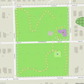
Interactive Park Map
About Bryant Park
A Glimpse into the Past
Tucked away at 1701 West Morehead Street in Charlotte's Historic Camp Greene neighborhood, the 8.7-acre Bryant Park feels like a living postcard from another era. Born in the 1930s as a Works Progress Administration (WPA) project, this park features an intricate network of stone walls and elevated seating overlooking the softball fields - showcasing Depression-era craftsmanship.
The land itself came from E. C. Griffith, one of Charlotte's notable developers of the time. While plans for the park began taking shape around 1929-1930, the Great Depression initially put a damper on progress. As one of the Charlotte Park and Recreation Commission's first undertakings, Bryant Park persevered despite these early challenges.
Character in Stone
Wander through Bryant Park and you'll notice something special about its layout - a gently terraced hillside flowing down to expansive green playing fields. The real stars here are the stone boundary walls and terrace structures, crafted during the height of the Depression, likely by WPA workers who left their mark on Charlotte's landscape.
Planning an event? Make a reservation at this park
These stone elements aren't just practical - they tell a story of resilience and public works that transformed the city during one of America's most challenging economic periods.
Where the Community Plays
At the heart of Bryant Park lies a well-maintained softball field that has hosted countless games over the decades. Nearby, a versatile multi-purpose public field serves whatever sporting need arises - though during peak seasons, soccer games dominate the space, bringing energy and friendly competition to the neighborhood.
Families with young ones will appreciate the playground area where kids can burn off energy while parents enjoy the park's relaxed atmosphere. The space accommodates both active participants and those who simply want to relax.
Community Connections
Keep an eye out for the occasional free concert that brings neighbors together under open skies. These events enhance Bryant Park's already welcoming vibe and strengthen community bonds in this historic corner of Charlotte.
A Landmark Preserved
The Charlotte-Mecklenburg Historic Landmarks Commission formally recognized what locals already knew when they designated Bryant Park as a historic landmark in 2003. This status acknowledges the park's important role in Charlotte's story.
Been to this park? Share a or a
Bryant Park's journey hasn't always been smooth. During the 1960s and 1970s, underfunding of the Charlotte Parks Commission coincided with aggressive industrial development along West Morehead Street. The park surrendered significant portions of its original footprint to this growth.
Today's Bryant Park occupies less than half of its original area, yet it continues to provide crucial green space in Charlotte's West Morehead industrial sector - a pocket of history and natural relief amid the urban landscape.
All Features & Facilities
Active Recreation
Nature & Wildlife
Visitor Services
Photo Gallery
Leave a Comment
Share your experience at this park
ParkMagnet Score
Decent Park
Park Size
Opening Hours
Plan Your Visit
Weather
Top Restaurants Near Bryant Park
Pinky's Westside Grill
702 feet1600 W Morehead St, Charlotte, NC 28208
Casual American restaurant serving sandwiches, hot dogs, tacos and cocktails in an offbeat atmosphere.
Counter-
787 feet2001 W Morehead St D, Charlotte, NC 28208
Upscale dining destination featuring a creative 10-course tasting menu with locally-inspired Piedmont cuisine and wine pairings.
Pizza Baby "West"
0.4 miles2135 Thrift Rd #101, Charlotte, NC 28208
Artisanal pizza restaurant featuring fresh ingredients, creative toppings, and house-made dipping sauces with excellent crust.