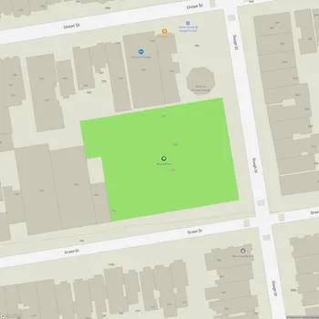
Buena Vista Park
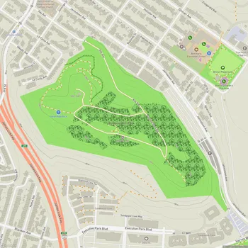
Interactive Park Map
About Buena Vista Park
Historic Roots
If these trees could talk... Buena Vista Park isn't just any green space - it's San Francisco's oldest official park, dating back to 1867. First called Hill Park (not the most creative name), it later earned its current Spanish moniker meaning "good view." And that name couldn't be more fitting.

The Climb Worth Taking
Spread across 37 acres of hilly terrain, Buena Vista Park peaks at an impressive 575 feet. Yes, you'll definitely get your steps in here! The reward for your effort? Breathtaking panoramic views that showcase Golden Gate Park, the Pacific Ocean, and on those crystal-clear San Francisco days (cherish them when they happen), you can see all the way to Drake's Bay.
Planning an event? Make a reservation at this park
Bring your hiking shoes - some trails get steep and can be a bit slippery, especially after the rain. What's fascinating is how the dense tree canopy creates this unexpected forest feel right in the middle of the city. It's like stepping into another world, where the urban noise fades behind you with each step upward.

Nature's Sanctuary
The park protects one of San Francisco's few remaining coastal live oak groves - a little piece of what this land looked like before the city grew around it. As you explore the winding trails, look down at the gutters - they have a story to tell. Built by WPA workers during the 1930s, these drainage channels incorporate broken headstones from Victorian-era cemeteries that were relocated to Colma. It's a bit eerie but fascinating to spot fragments of history literally beneath your feet.
Look up and you might catch glimpses of hummingbirds darting between the trees, jays calling out, or if you're lucky, hawks soaring overhead. The diverse canopy of eucalyptus, pine, and Australian tea tree creates a microhabitat that feels miles away from downtown.

Picture-Perfect Perspectives
The park's natural layout offers several spots where you can stop and just soak in the view. "The Window" on the western hillside is particularly special - a natural frame for the expansive vista beyond.
Been to this park? Share a or a
Make it to the summit and you're in for a treat: panoramic views that stretch across San Francisco, with both the Golden Gate and Bay Bridges visible on clear days. Bring your camera or just bring yourself - either way, these viewpoints offer a moment of peaceful perspective above the bustling city.

Take a Break
Need a break from hiking? The tennis courts near the Haight Street entrance offer a change of pace. If you've got kids in tow, there's a small playground with the essentials to keep them entertained.
Picnic opportunities abound, whether you prefer proper designated areas or just finding your own perfect grassy spot to spread out a blanket. And yes, your four-legged friends are welcome too - just keep them leashed to protect both the local wildlife and other visitors enjoying their day.
Don't miss the wooden boardwalk below the peak on the western side. This charming path winds through the trees, offering excellent views and a slightly easier walking surface than some of the dirt trails.

Evolving with Time
Like most long-standing parks, Buena Vista has seen its share of changes. The late 1970s and early 1980s brought erosion control measures and path improvements. More recently, recreational facilities have been upgraded and new landscaping added.
Today, this urban hillside offers a peaceful retreat - a place where you can disconnect from city life while still being right in the middle of it. No matter if you're seeking exercise, solitude, or just a different perspective on San Francisco, Buena Vista Park provides that "good view" its name promises.
All Features & Facilities
Active Recreation
Nature & Wildlife
Visitor Services
Food & Gathering
Photo Gallery (click to enlarge)

Leave a Comment
ParkMagnet Score
Good Park
Park Size
Opening Hours
Plan Your Visit
Weather
Top Restaurants Near Buena Vista Park
KEN
863 feet252 Divisadero St, San Francisco, CA 94117
Intimate six-seat sushi counter offering high-end Edomae omakase with expertly crafted dishes and personalized service.
Jalebi Street
948 feet1466 Haight St, San Francisco, CA 94117
Authentic North Indian restaurant specializing in traditional chaat dishes and fresh vegetarian fare.
Nepa Indian Cuisine
0.3 miles507 Divisadero St, San Francisco, CA 94117
Authentic Nepalese and Indian restaurant serving flavorful dishes including excellent momos and tandoori specialties.
L'Ardoise Bistro
0.3 miles151 Noe St, San Francisco, CA 94114
Intimate neighborhood bistro serving elegant traditional French cuisine with excellent duck, lamb, and seasonal specialties.
Altamirano Restaurant & Bar
0.4 miles1775 Fulton St, San Francisco, CA 94117
Authentic Peruvian restaurant featuring creative ceviches, lamb dishes, and pisco cocktails in a vibrant atmosphere.
Ju-Ni
0.4 miles1335 Fulton St STE 101, San Francisco, CA 94117
Contemporary upscale sushi restaurant offering intimate omakase experiences with exceptional fish quality and skilled preparation.
Top Hotels Near Buena Vista Park
The Metro Hotel
974 feet319 Divisadero St, San Francisco, CA 94117
Family-owned hotel featuring minimalist rooms with free Wi-Fi and a charming private garden space.
Beck's Motor Lodge
0.4 miles2222 Market St, San Francisco, CA 94114
A renovated motel featuring clean, colorful rooms with modern amenities and free parking in a walkable neighborhood.
The Hotel Castro
0.5 miles4230 18th St Unit A, San Francisco, CA 94114
Modern boutique hotel featuring self-service check-in, thoughtfully appointed rooms with balconies, and an on-site lobby bar.
Stanyan Park Hotel
0.5 miles750 Stanyan St, San Francisco, CA 94117
Historic Victorian hotel across from Golden Gate Park offering complimentary breakfast and evening wine service.
The Grove Inn
0.6 miles890 Grove St, San Francisco, CA 94117
Elegant inn offering bright, clean rooms with complimentary Wi-Fi in the charming Alamo Square neighborhood.
Chateau Tivoli Bed and Breakfast
0.7 miles1057 Steiner St, San Francisco, CA 94115
Victorian mansion bed and breakfast featuring elegant period furnishings and homemade breakfast in historic surroundings.