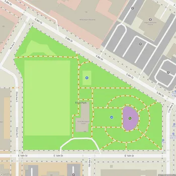
Harrison Park
Interactive Park Map
About Harrison Park
Park Overview
Positioned in Minneapolis's Harrison neighborhood, Harrison Park is a 6.9-acre green space that's been part of the community since 1909. Bordered by Highway 55 and North Irving Avenue, this park has evolved into something special over the decades. It's a clean, welcoming space, particularly nice for families looking for a break from city life.
A Bit of History
The Minneapolis Park Board officially brought Harrison Park into the fold in 1959, but they'd already been developing a playground there since 1958. The park takes its name from the adjacent Harrison School, which itself was named after William Henry Harrison, America's ninth president. Not the longest-serving president (he died after just 31 days in office), but his legacy lives on in this vibrant community space.
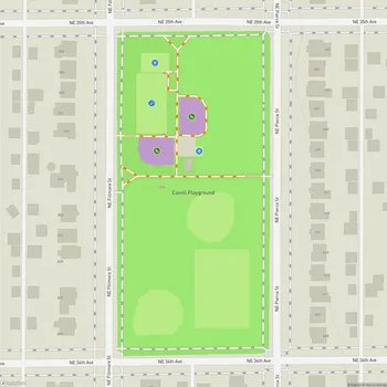
What You'll Find Inside
At the heart of Harrison Park stands a modern community center that serves local residents. Inside, you'll find a spacious gymnasium and a kitchen that hosts various community gatherings. The center brings together people of various ages and backgrounds.
Planning an event? Make a reservation at this park
One of the park's newer additions is the wading pool installed in 2015. The pool features colorful play elements that function as a splash pad during Minnesota's warmer months. At just 2 feet deep, it's suitable for younger children, and it's free to use.
Thirsty after all that play? There are drinking fountains placed around the grounds for use during hot summer days.
Kid Paradise: The Playground
The playground is popular with children. It's got all the classics: swings (both regular and baby-sized), monkey bars for the climbers, and various spinning rides that'll leave kids gleefully dizzy. There's also an individual teeter ride on springs that's always in high demand.
Been to this park? Share a or a
Beyond the usual slides and tire swing, what really catches kids' attention is the unique train display complete with decorative chickens. These unique elements add character to Harrison Park.
Getting Better with Age
The late '90s and early 2000s brought major upgrades to Harrison Park. Between 1997 and 1999, the old school and recreation shelter made way for a new secondary school and neighborhood center. This new building houses a gym, park board neighborhood center, and offices for the Harrison Neighborhood Association.
The playground and other areas got their own facelift in 2003-2004, ensuring the park stays relevant and functional for new generations.
Fresh Air Activities
When the weather permits, the park's outdoor areas offer various activities. Picnic tables dot the open spaces, great for everything from birthday celebrations to casual weekend lunches.
Sports enthusiasts can take advantage of the baseball field, basketball court, and soccer field. If organized sports aren't your thing, there are plenty of open grassy areas to toss a frisbee or fly a kite. The community gardens offer a chance to get your hands dirty, while paved paths and walking trails provide scenic routes for a morning jog or evening stroll.
Community at Heart
Harrison Park plays an important role in the community. During summer months, the park participates in the summer meals program, offering free weekday snacks and meals for kids under 18 - a vital service for many families.
Looking to host an event? The park's facilities are available for rent, making it a go-to spot for birthday parties and gatherings that need a little more space than your average living room can provide.
All Features & Facilities
Active Recreation
Nature & Wildlife
Water Features & Activities
Visitor Services
Food & Gathering
Photo Gallery
Leave a Comment
ParkMagnet Score
Good Park
Park Size
Opening Hours
Plan Your Visit
Weather
Top Restaurants Near Harrison Park
La Mesa
0.5 miles230 Cedar Lake Rd S, Minneapolis, MN 55405
Neighborhood Latin American bistro serving regional dishes with authentic flavors and a welcoming patio atmosphere.
Bryn Mawr Pizza & Deli
0.6 miles404 Cedar Lake Rd S, Minneapolis, MN 55405
Family-owned pizzeria serving authentic Italian-style pizza, hearty hoagies, and comfort food in a welcoming neighborhood setting.