Williamsbridge Oval
Interactive Park Map
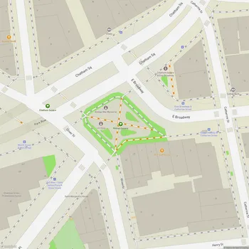
About Williamsbridge Oval
History
Tucked away in the Norwood section of the Bronx lies Williamsbridge Oval, a 19.7-acre recreational haven with a fascinating backstory. This wasn't always a place for picnics and play - back in the late 19th century, this site housed the Gun Hill Williamsbridge Reservoir. When the reservoir was drained in 1925, it left behind a great opportunity for transformation.
During the 1930s, as part of President Franklin D. Roosevelt's New Deal programs, specifically the Works Progress Administration (WPA), what was once a utilitarian water source became a community treasure. Construction kicked off in 1934, and by 1937, Williamsbridge Oval Park was ready to welcome the public - a silver lining of the Great Depression era that continues to serve the neighborhood today.
Design Features
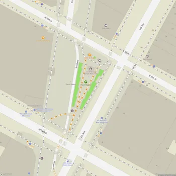
The park cleverly preserves the original oval shape of the former reservoir, complete with its distinctive 46-foot high embankment. Walking through the park, you'll notice multiple pathways that circle this oval, each offering a slightly different experience.
Planning an event? Make a reservation at this park
The inner walking path sits at ground level and takes you past all the recreational areas, while the elevated upper path provides a more peaceful route with plenty of benches for those moments when you need to catch your breath or simply watch the world go by.
Make your way to the corner of Bainbridge Avenue and Van Cortland Ave. East, and you'll discover the park's main entrance - a large concrete tunnel that serves double duty as both an impressive gateway and a handy shelter when sudden rain showers hit.
Recreational Facilities
No matter if you're a serious athlete or just looking to move your body, Williamsbridge Oval offers plenty of options. The park features well-maintained basketball courts, tennis courts, and freshly updated pickleball courts complete with new nets and shaded areas to escape the summer sun.
Been to this park? Share a or a
The turf field draws soccer enthusiasts and football players alike, including the young athletes of the Bronx Buccaneers who hold their practices here. Surrounding the field is a running track where you'll find locals getting their cardio in at all hours.
Not into running or team sports? Try your hand at the bocce courts, hit up the volleyball areas, or watch skaters of all skill levels at the skate park - or better yet, bring your board and join them!
Children's Areas
If you're bringing little ones along, you'll discover multiple playgrounds scattered across the park, each equipped with jungle gyms, slides, and swing sets that will keep kids entertained for hours. When summer temperatures climb, the popular splash pad becomes the neighborhood hotspot, with water fountains that provide endless giggles and cool relief.
The playgrounds are thoughtfully designed for different age groups, so toddlers and older kids each have appropriate spaces to play. Weekend visits often come with a bonus - organized crafts and special programs that add an extra dimension to your family park day.
Community Amenities
Dog parents will appreciate the dedicated dog run with separate sections for large and small pups, allowing for safe socialization. Planning a gathering? The multiple picnic areas with tables offer perfect spots for birthday celebrations or casual meet-ups, however note that you'll need to bring pre-prepared foods as cooking facilities aren't available.
The park's recreation center is a hub of community activity, offering various programs and fitness classes like yoga and cardio kickboxing. When nature calls, restrooms are conveniently located near the recreation center, with separate facilities for men and women.
Through all seasons, the garden areas and shaded benches provide peaceful retreats where you can lose yourself in a book, have a heart-to-heart conversation, or simply enjoy a quiet moment surrounded by nature in the midst of city life.
Renovations and Community Impact
Williamsbridge Oval hasn't remained frozen in time since its 1930s creation. Over the years, it has received several renovations, including recent multi-million dollar upgrades that have enhanced its facilities for current and future generations.
The park's cleanliness stands out - reflecting the work of staff who maintain this community space. Open daily from 6AM to 10PM, it represents a crucial recreational resource for Norwood residents and visitors from across the Bronx.
Sundays are particularly special at Williamsbridge Oval, with regular community events that bring neighbors together. As seasons change, so do the activities, but the park continues to serve as a tranquil urban space where neighbors can connect amid the greenery.
All Features & Facilities
Active Recreation
Nature & Wildlife
Water Features & Activities
Visitor Services
Food & Gathering
Photo Gallery
Leave a Comment
ParkMagnet Score
Great Park
Park Size
Opening Hours
Plan Your Visit
Weather
Top Restaurants Near Williamsbridge Oval
Wai Kang
0.5 miles39 Bedford Park Blvd, Bronx, NY 10468
Chinese restaurant serving traditional dishes including chicken noodle soup and Chicken MeiFun in a clean environment.
Hudson Garden Grill
0.8 miles2900 Southern Blvd, Bronx, NY 10458
Polished New American restaurant located within the Botanical Garden offering scenic arboretum views.
New Capitol
1.2 miles2 W Kingsbridge Rd, Bronx, NY 10468
Classic 24-hour diner featuring traditional American comfort food in a vintage setting with counter seating.