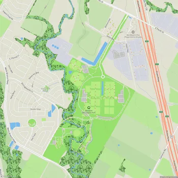
Barton Creek Greenbelt
Interactive Park Map
About Barton Creek Greenbelt
Natural Features
Situated in the heart of Austin, the Barton Creek Greenbelt stretches 7.25 miles from central Zilker Park westward to the Lost Creek neighborhood. Managed by the City of Austin's Park and Recreation Department, this urban wilderness provides a natural escape from city life without having to leave town.
When you step onto the greenbelt, you're immediately surrounded by its distinctive limestone cliffs, lush vegetation, and the winding path of Barton Creek. The creek itself is something of a Texas weather diary - sometimes flowing generously after rain, other times reduced to a dry creek bed during drought periods. It's nature's way of keeping things interesting.
Popular Swimming Areas
Twin Falls and Sculpture Falls are the greenbelt's most popular swimming areas. On hot summer days (and let's be honest, in Austin that's most days), these natural swimming holes become the city's favorite cool-down spots. The water level is entirely dependent on recent rainfall though, so it's worth checking conditions before you grab your towel and sunscreen.
Planning an event? Make a reservation at this park
When the creek is flowing, expect refreshingly cool water cascading over smooth limestone formations, creating natural pools that are meant for a leisurely dip or peaceful float. The small waterfalls add both beauty and a soothing background soundtrack of flowing water.
Greenbelt Sections
The greenbelt divides into three main areas: the Lower Greenbelt, Upper Greenbelt, and Barton Creek Wilderness Park, each with its own character and challenges.
You'll find the terrain varies considerably as you explore - from beginner-friendly flat paths near Zilker to more adventurous trails with elevation changes as you head west. This natural diversity means you can match your route to your mood and fitness level, whether you're up for a casual stroll or looking to push yourself a bit harder.
Recreational Activities
The greenbelt accommodates a wide range of outdoor activities. Hikers and trail runners navigate its paths daily, while mountain bikers tackle its more technical sections with glee. Rock climbers and boulderers test their skills on the limestone cliffs that punctuate the landscape.
Been to this park? Share a or a
The greenbelt is also a paradise for four-legged friends, but you should keep your dog leashed for everyone's safety and enjoyment. Nothing beats watching your pup experience the joy of exploring new scents and terrain alongside you.
Trail Information
Navigating the main trail is fairly straightforward - it's wide and well-traveled. That said, part of the greenbelt's charm lies in its network of smaller side trails that invite exploration and sometimes lead to peaceful escapes off the beaten path.
The tree canopy provides welcome shade for much of the route, making even summer hikes more bearable. Just be aware that trail markers aren't always obvious, so having a map or trail app handy isn't a bad idea, especially for first-timers.
You'll want to wear proper footwear - the terrain can get rocky and uneven in places. Some sections definitely aren't stroller-friendly or easily accessible for those with mobility challenges.
Ecological Importance
Beyond recreation, the greenbelt functions as a vital ecological corridor in Austin's urban landscape. It provides crucial habitat for local wildlife and plant species, including some that are endangered. The area also acts as a natural filter for water flowing into Barton Springs Pool, helping maintain the water quality of this popular swimming spot.
Keep your eyes open while exploring - you might spot native birds, sunbathing turtles, and yes, occasionally snakes (from a respectful distance, of course). These encounters remind us we're guests in their home.
Access Points
You can enter the greenbelt from several trailheads, with major access points at Zilker Park, Spyglass Drive, Loop 360, and Trail's End near Camp Craft Road.
Most trailheads offer parking, but spaces fill quickly on pleasant weekends and holidays. Unfortunately, car break-ins have been reported at some lots, so it's best to leave valuables at home or take them with you on the trail.
Visitor Tips
Bring more water than you think you'll need, especially during warmer months. There are no drinking fountains along the trails, and Texas heat doesn't mess around. Similarly, bathroom facilities are scarce - plan accordingly.
For the most peaceful experience, try visiting on weekday mornings or late afternoons. Spring and fall offer the most comfortable temperatures, although each season brings its own unique beauty to the greenbelt. Early morning visits often reward you with magical light filtering through the trees and a better chance of spotting wildlife.
All Features & Facilities
Active Recreation
Nature & Wildlife
Water Features & Activities
Visitor Services
Food & Gathering
Photo Gallery
Leave a Comment
Share your experience at this park
ParkMagnet Score
Great Park
Park Size
Opening Hours
Plan Your Visit
Weather
Top Restaurants Near Barton Creek Greenbelt
Crepe Crazy
0.3 miles3103 S Lamar Blvd, Austin, TX 78704
A charming creperie serving both savory and sweet crepes with generous portions and excellent coffee.
Jet's Pizza
0.3 miles3003 S Lamar Blvd F130A, Austin, TX 78704
Counter-serve chain specializing in Detroit-style pizza with flavored crusts, wings, and submarine sandwiches.
Grata’s Pizzeria
0.4 miles2700 S Lamar Blvd, Austin, TX 78745
Family-run pizzeria serving authentic pizza and Philly cheesesteaks on fresh Liscio's rolls from Philadelphia.
Top Hotels Near Barton Creek Greenbelt
Holiday Inn Express & Suites Austin SW - Sunset Valley by IHG
0.3 miles4892 US-290, Sunset Valley, TX 78735
Modern hotel featuring comfortable rooms, outdoor pool, fitness center, and complimentary breakfast and parking.
Hotel Viata
1.1 miles320 S Capital of Texas Hwy, West Lake Hills, TX 78746
Upscale hotel featuring comfortable accommodations with a restaurant, bar, fitness center, and outdoor pool.