Shelby Park
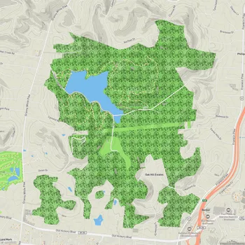
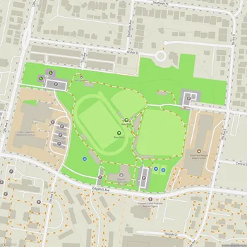
Interactive Park Map
About Shelby Park
A Glimpse into the Past
Shelby Park has a pretty fascinating origin story. What started as a private amusement park back in the 1890s officially became public property on July 4, 1912. Over the decades, it's transformed into a beloved green space for East Nashville locals and anyone looking for a breath of fresh air.
You can still spot bits of history around the park, like the cast-concrete water fountain shelter near the Lillian Avenue entrance. It was designed by Major Eugene Lewis, who headed Nashville's Parks department when the park was established. While many of the original architectural "follies" haven't survived the test of time, you can still discover remnants like the Cave Spring area if you know where to look. The park also has a small footnote in film history: a handful of scenes from the 1991 horror comedy Ernest Scared Stupid were shot on location here.
Planning an event? Make a reservation at this park
For many Nashvillians, this park holds cherished memories. Some locals reminisce about playing little league football and baseball here on Saturday mornings back in the 1970s. The land originally belonged to the Shelby family, and a few structures from that era continue to stand today.
What You'll Find Here
Covering nearly 361 acres, Shelby Park offers an impressive variety of landscapes - from bluffs and rolling hills to floodplains. It sits about three miles east of downtown Nashville along the Cumberland River, making it accessible yet feeling worlds away from city life.
At the heart of the park lies Lake Sevier, surrounded by winding drives and footpaths that largely follow the original 1919 design. It's common to see people watching the ducks and geese that call the lake home. Near the water, you'll also notice Reflection, a 12-foot-tall stainless steel mockingbird by artist Lawrence Argent, mounted on a granite plinth in a plaza near the event field. Installed by Metro Arts, it's hard to miss and makes a useful landmark for orienting yourself in that part of the park.
Been to this park? Share a or a
The park balances natural areas with recreational facilities, and you'll discover plenty of parking spots scattered throughout the grounds.
Get Moving
For the active visitor, Shelby Park offers several options. The grounds feature tennis courts, basketball courts, baseball fields, and soccer fields for team sports enthusiasts. Golf lovers can enjoy the 9-hole course, while the popular disc golf course draws players year-round regardless of the weather.
There's a playground with swings, slides, and climbing structures. Parents will appreciate the safety-focused padded ground material and the convenient picnic areas nearby.
Water enthusiasts can take advantage of the boat ramp for Cumberland River access, fantastic for fishing or taking your boat out for a spin. The lake area also attracts fishing fans looking for a peaceful spot to cast a line.
Gather and Feast
Throughout the park, you'll discover numerous picnic areas with tables, many featuring grilling facilities for impromptu cookouts. Several pavilions and gazebos provide shelter, making this an ideal spot for family reunions or casual get-togethers. Look for the larger gazebo with grills at the bottom of a hill, with additional picnic tables situated near the playground and tennis courts.
Hit the Trails
One of Shelby Park's highlights is its network of walking and biking trails. Both paved and natural paths wind through the property, with the paved ones circling Lake Sevier and connecting different park sections. The trail network also includes off-street paths for cyclists, runners, and walkers that link to surrounding neighborhoods. Worth noting: some pedestrians mention that not all paths connect seamlessly, so you might need to chart your route beforehand.
Many trails offer ample shade - a blessing during Tennessee's sweltering summer months. As you explore, you might catch glimpses of deer and other wildlife, especially in the no-mow zones and natural areas that provide habitats for local creatures, including bees and various bird species.
Bring Your Four-Legged Friends
Dog owners particularly love Shelby Park. While your pup needs to stay leashed in most areas, there's a dedicated dog park where they can run free. This fenced space offers plenty of room with trees and grass, plus benches where you can relax while your dog socializes. You'll find it conveniently located near a playground and the local elementary school.
Nature Escapes
Despite being relatively close to downtown, Shelby Park feels like a genuine escape into nature. Extensive wooded areas and open fields create a peaceful atmosphere that lets you temporarily forget you're in the middle of a major city.
The park provides access to the Cumberland River, offering both fishing opportunities and lovely views of the waterway. Keep an eye out for the wetland areas that become hotspots for migratory birds during fall and winter.
Beyond the Boundaries
Shelby Park connects to the larger Shelby Bottoms Greenway and Natural Area, essentially extending your outdoor adventure possibilities. This connection opens up even more hiking and biking options, linking the park to Nashville's broader network of green spaces.
The surrounding green space grew further in 2011 when Nashville acquired the adjacent Cornelia Fort Airpark, pushing the combined acreage of Shelby Park, Shelby Bottoms, and the airpark to over 1,000 acres. The airpark is named for aviator Cornelia Fort and carries a somber place in music history - it was the intended destination of country singer Patsy Cline when the plane she was traveling on crashed on March 5, 1963.
The Practical Stuff
The park includes a Nature Center where you can check out educational displays about local plants and animals. Clean restrooms are available near the visitor center entrance, with portable toilets stationed at various points throughout the park. You'll discover water fountains in select locations, particularly near the visitor center - handy for refilling your bottle on hot days.
All Features & Facilities
Active Recreation
Nature & Wildlife
Water Features & Activities
Visitor Services
Food & Gathering
Photo Gallery
Leave a Comment
ParkMagnet Score
Top Park
Park Size
Opening Hours
Plan Your Visit
Weather
Top Restaurants Near Shelby Park
Two Ten Jack
0.6 miles1900 Eastland Ave #105, Nashville, TN 37206
Modern Japanese izakaya serving creative small plates, ramen, sushi, and craft cocktails in a chic atmosphere.
Graze Nashville
0.6 miles1888 Eastland Ave, Nashville, TN 37206
Plant-based restaurant serving creative vegan breakfast, lunch, and dinner dishes with craft cocktails in a relaxed atmosphere.
Rosepepper Cantina
0.6 miles1907 Eastland Ave, Nashville, TN 37206
Mexican fusion restaurant featuring creative margaritas and flavorful dishes served in a festive atmosphere.
Top Hotels Near Shelby Park
Waymore's Guest House & Casual Club
1.2 miles811 Main St, Nashville, TN 37206
Stylish boutique hotel featuring comfortable rooms, rooftop bar, all-day diner, and 24-hour fitness center.